
Strengthening Ottawa’s Centre: The Case for Renewal on Merivale Road
If you live and drive in Ottawa, chances are you’ve been on Merivale, probably a number of times. The road is, after all, hard to avoid. Located at the geographic heart of the city, the Merivale Arterial Mainstreet (its official zoning designation) is a hub of commercial and industrial activity and is meant to offer a handy North-South commuting corridor.
A closer look, however, reveals a different Merivale: a congested roadway, mired in a 1970s paradigm of cars, big box-stores and endless parking lots, a source of increasing frustration for shoppers, commuters as well as local residents and business owners.
This contrast between purport and reality opens an interesting choice for those who like me live in the Merivale Sub-area of Ottawa. On the one hand, we could erect giant billboards at each end of the road warning drivers “better to avoid this one”. On the other, we could get down seriously to the business of fixing our neighbourhood’s main street.
Personally, I favour the second option.
A renovated Merivale road would reduce downtown commuting time and help rationalize traffic patterns citywide. It would make it easier for local business to ply their trade, to offer their many goods and services to all City residents. It would give Ottawa a chance to design a key arterial mainstreet for the needs of pedestrians, cyclists, and transit users as well as motorists, thus helping residents to reduce their dependency on automobiles and promoting a true urban life-style based on trendy neighbourhoods.
And finally, it would contribute to the emergence of a Mid-Town, a major secondary business centre within a lively residential neighbourhood, located right in the middle of a city that now extends from Kanata to Orléans.
To summarize my goals: I would like the Merivale corridor and sub-area of town to be:
- a desirable place to live and raise a family;
- a good place to conduct business;
- an efficient thoroughfare to commute to the inner core of the city; and
- an attractive Mid-Town destination for all Ottawa residents
Can these goals be achieved without breaking the bank? And if so, how would we get the ball rolling?
Let’s start by taking a fresh look at the National Capital Region.
The two maps below illustrate how Ottawa’s downtown would have been ideal for a federal district straddling Quebec and Ontario.
A circle of 15km in radius centered at Parliament Hill (Map A) covers the entire city of Gatineau (Québec) as well as all pre-1980s Ottawa, which lies within the Green Belt.
By contrast, a 15km circle centered at the Merivale-Meadowlands intersection (Map B) covers Bell’s Corner, Barrhaven, Gloucester, Leitrim and other new Southern subdivisions, in addition to all inner Ottawa West of Saint-Laurent.
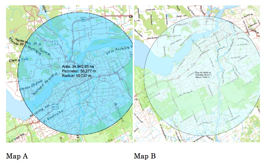
There is no avoiding the conclusion that Ottawa’s inner core is off-centre, by a wide margin. As the city continues to expand, the West and South faster than the rest, the City’s historical downtown becomes increasingly remote, more difficult to reach even by car.
Connecting an eccentric downtown core to a dispersed population is Ottawa’s greatest infrastructure challenge. For decades, the City has been jumping through hoops. It has invested massively in roads, highways, and now is planning to spend vast amounts of money for a mass transit (buses, O-Train and Light Rail Transit) that will enable residents living along an East-West axis as far away as Orleans and Kanata to reach the inner city in less than an hour.
It’s a costly policy, especially for a city of just over 1 million and the burden will be entirely borne by the local population, in the form of both municipal and provincial taxes.
As a complement if not an alternative to this policy, it would be very effective to allow some downtown business and cultural assets to migrate to a Mid-Town, located closer to where a majority of the population live and therefore more convenient for them to reach.
The creation of a Mid-Town would imply little additional new infrastructure (roads, sewage, water, power, and transit are already available), and the cost of its development would essentially be borne by the private sector.
As to the second question: how to get the ball rolling, I must admit it’s a challenge.
Primarily because so many people and institutions are stakeholders: Ottawa residents especially those living in the Merivale sub-area; the business community; the City: both Council and Administration; and the Province of Ontario, notably the Department of Municipal Affairs and Housing.
In addition nothing will happen without a plan. A plan that proposes sound solutions to real problems, whose logic and details will be widely discussed, and which will have to be amended so as to attract broad support among all interested parties.
A hefty challenge, yes, but no reason to despair. As it turns out, Councillors Keith Egli and Rick Chiarelli got things started in September 2013 when they jointly invited the Knoxdale-Merivale Council of Community Associations (KMC, chaired by Agnes Warda) and other neighbourhood association representatives from Wards 8 and 9 to a meeting with City Planners in order to discuss Ottawa’s new Arterial Mainstreets Densification Initiative.
In line with Ontario’s intensification guidelines, the City had decided that all Arterial Mainstreet (AM) should, by 2031, be developed to a density of 120 jobs/residents per Hectare. (Right now, Merivale with about 60 jobs/residents per hectare has half the desired density).
These AM zones correspond to major streets across the city, including for instance Carling Avenue, St. Laurent Boulevard, Montreal Road, and Robertson Road, as well as Merivale Road. Their zoning bylaw allows for a very wide spectrum of uses: from high density residential to business and commercial buildings as well as retail outlets.
Across the entire city, there are a number of zones targeted for more rapid or more intense development, most of them zoned other than AMs, but, as the following map reveals, few if any zones, and certainly no other AM zone, match Merivale Road for size, compactness, and location.
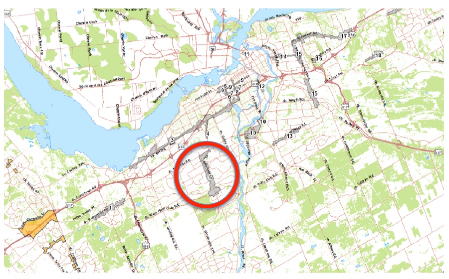
The September 2013 meeting was a low-key, informal opportunity for the City to float the idea that major pieces of the town could be re-imagined, reinvented. The two Councillors’ initiative raised the question: how might the whole community –residents (and their neighbourhood associations), private sector (business, developers, and landowners), and town officials— redefine the Merivale AM zone, a chunk of more than 400 acres of urban space, to better fulfil the needs of local residents and respond to the life-style of a creative society?
Is it conceivable to re-imagine big under-developed AM zones as if they were blank canvases? You might not think so given that the Merivale Road AM zone appears already built-up.
But is it really built up as fully as that?
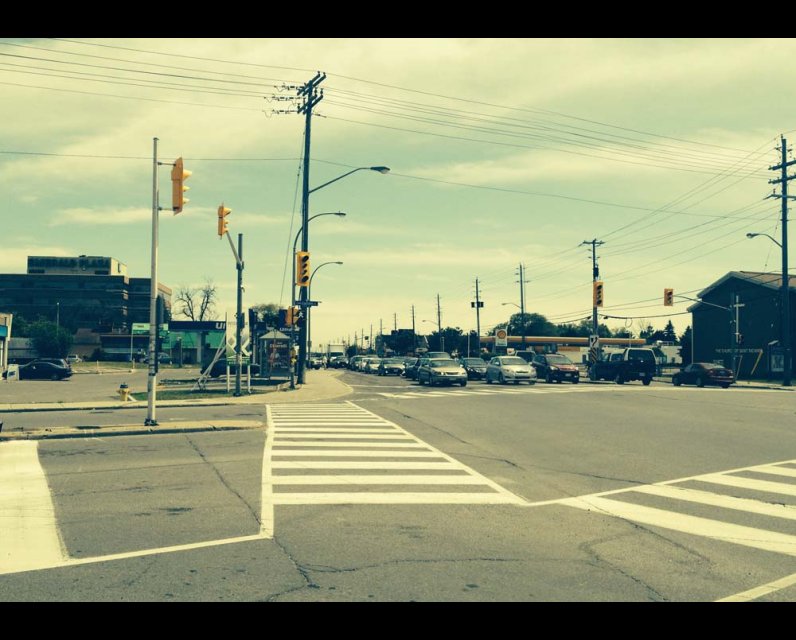
An aerial view of Merivale Road reveals that parking lots take up at least half the space. Big box stores, cheap one-storey structures built on a cement platform and vacant lots make up most of the rest, giving the corridor, from Baseline to West Hunt Club, the unfinished look of a string of Second World War temporary buildings.
From an architecture and ergonomic perspective, big-box stores are wasteful volumes and dysfunctional retail outlets. On top of that, on Merivale Road the cost of building them has been fully amortized. If these were houses, they would be deemed teardowns.
OK, if there is so much room for development along Merivale Road, why are change, modernization and densification not happening right now, as a result of private initiative?
Good question.
The property owners, developers and retailers to whom I have spoken assure me that they would love to serve a larger clientele more efficiently, that they are eager to invest and offer more to more people. Trouble is, stores, shops and businesses on Merivale are literally handcuffed to cars, structured to market almost exclusively to cars and their drivers.
To operate at top efficiency, an active high street has to be accessible to everyone: pedestrians, cyclists, bus or LRT riders as well as drivers. Simply because these are the four ways to go about in a city: walk; cycle; transit; and drive.
Retail and business along Merivale acknowledge that road and zone were originally designed to accommodate cars and that today they still privilege the owners of private vehicles and ignore the rest of their potential clientele.
Their first misfortune is that, an increasing number of people walk, cycle or rely on public transportation.
Their second and main misfortune is that every day, rain or shine, summer or winter, Merivale road chokes up on its cars.
Business complain that the lack of “mobility” along the Merivale corridor discourages would be customers and therefore harms their activities. As a consequence, property owners and retailers walk in the footsteps of bears rather than bulls. A majority of them have opted to wait for a better day before they launch large investment ventures. Of course, all is not at a standstill. There is activity along the corridor –Walmart a few years ago, Target in 2013 and right now the Honda dealership at Colonnade and Claridge Homes with their Stirling Park condominiums across from the Merivale Mall– but this inflow of new facilities is a trickle compared to the potential and, in too many cases, it fails to meet the forthcoming 120 jobs/residents per hectare criterion.
Though I might dislike that the Merivale Triangle (at Clyde, Merivale and Baseline) remains a big empty field (all 14 acres of it), I do acknowledge that business are acting rationally: mobility along Merivale is inadequate.
Among the five main North-South roads in the area (Greenbank, Woodroffe, Merivale, Fisher, and Prince of Wales), Merivale is the worse commute choice. Of course, it does not help Merivale to be located right down the middle of these 5 roads, to be the only Arterial Mainstreet (160 hectares of commerce) among them and to have a major industrial park south of Hunt Club West.
To add insult to injury, Merivale Road is not particularly well designed. Buses mingle with cars and trucks and, since there are no bus bays, slow down traffic and impede motorists turning right at intersections.
The absence of right turning lanes, or median separators leaves many turns unprotected.
On average there is a traffic lights every 250m, at the entrance of many shopping malls in addition to street crossings.
And finally, road or utilities maintenance and delivery trucks often block one traffic lane at any hour of the day.
All in all, Merivale Road can be a tale of woe for a businessperson, even an enterprising one.
If I may summarize:
Back in September a year ago, the City started a promising rejuvenation process along Merivale Road with its new AM Densification Policy.
But, in spite of its merits, this initiative will likely fail to pull Merivale out of its rut, at least unless the traffic and congestion problem has been tackled.
When I initially drafted this article, I stopped right here with a plea for ideas and contributions.
Then I wondered whether it would not be more effective to put forward a few suggestions in the hope that they would draw comments, trigger other and better ideas, and generally prompt a vigorous and fruitful public discussion on the renewal of Merivale Road.
This led me to address the following question:
How can Merivale Road and AM zone be rebuilt so as to optimize all four types of mobility? And without imposing a big new burden on Ottawa taxpayers?
I came up with five ideas, which I now offer to kick-start the discussion.
- 1. A high volume transit link between Mid-Town Merivale and Downtown Ottawa
- 2. A central-lane rail transit spur along Merivale
- 3. Merivale Road optimized for traffic from Slack to Baseline
- 4. Grant Carman extended to create an efficient Merivale grid
- 5. Create integrated networks of pathways and bikeways to cover the entire Merivale AM zone.
I hasten to say that these 5 ideas are fully consistent with Ottawa’s present Transportation Master Plan.
1. A High Volume Transit link between Mid-Town Merivale and Downtown Ottawa
The City has been studying the enlargement of Baseline Road to accommodate two median Bus-only lanes.
The idea has potential, but the scope of the project, from Woodroffe Avenue to Riverside Drive, seems far too narrow to make a real difference.
To be effective a high volume transit line on Baseline, Merivale, or any other major avenue, has to connect with the rest of the system, to be integrated into a seamless mass transit network.
That objective is not out of reach. With only three amendments to the existing “affordable version” of the Transportation Master Plan, it would be possible to plug in the Merivale AM zone into the LRT system.
- 1. Run a Light rail line instead of buses along Baseline, with its starting point at Woodroffe/Baseline LRT Station
- 2. Connect this rail line to the O-Train (junction at Confederation Station)
- 3. At its end point, connect this rail line to LRT at Heron Station
2. A central-lane rail transit spur along Merivale
- Such a spur would provide a logical complement to an LRT running along Baseline
- The spur would run from Baseline-Merivale the MacFarlane-Merivale Railway crossing
- As on Baseline, the LRT would use two median lines
- It would make sense to place 3 Stations along the line:
- At the Baseline-Merivale Junction
- At the Merivale Clyde split to serve the Merivale Triangle
- At MacFarlane Road
There would also be a need for a small number of strategically placed on-off platforms along the way.
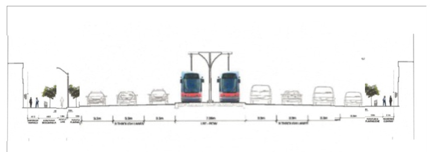
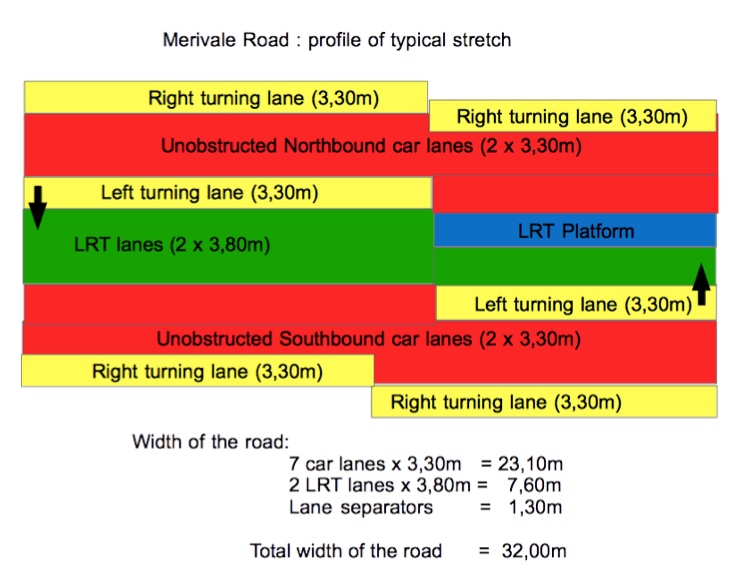
3. Merivale Road optimized from Slack to Baseline
The City has, on average, a 35m Right-of-way along Merivale Road so it is quite feasible to enlarge and rationalize the roadway to a much higher standard of convenience, without proceeding to expropriations.
The idea is to provide a total of seven car lanes: two unobstructed drive-trough lanes and a single right turning lane in each direction, as well as an intermittent left-turning lane (see illustrations below).
A number of other measures would also be called for, such as a reduction in the number of traffic lights, better synchronisation among those left, new incentives to property owners to share parking lots and accesses to Merivale Road, and so forth.
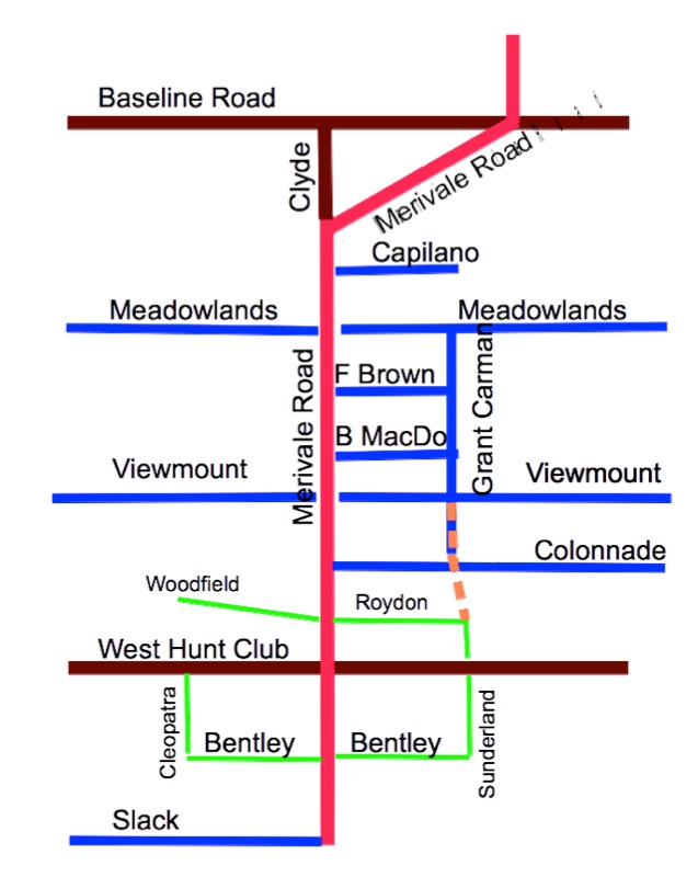
4. Grant Carman extended to create an efficient Merivale grid
It is a particularity of the Merivale AM zone that the Grant Carman Drive runs parallel to the main road from Meadowlands to Viewmount. The extension of Grant Carman to Colonnade and, later, its connection to Roydon would create a real service road for the central section of the corridor. This would relieve pressure on Merivale and offer drivers alternative routes to go from Meadowlands to West Hunt Club.
5. Integrated networks of pathways and bikeways to cover the entire Merivale AM zone
In general, Ottawa sidewalks and bike trails are tied to streets and roads and subordinated to vehicular traffic.
Merivale’s sidewalks, from Baseline to West Hunt Club are meaningless, they border on nothing and seem to have no other purpose than serve as snow disposal sites during winter.
In addition they are dangerous and disconnected: exposing pedestrians to high velocity traffic and failing to lead to the entrance of most commercial or residential sites.
In the Merivale AM zone, bikeways are non-existent although, judging from the occasional bike stand, it would seem that bikes are known to exist and be used.
It would be far more efficient to build a network of walkways and a network of bikeways that both provide direct, safe and easy access to all establishments in the Merivale AM zone.
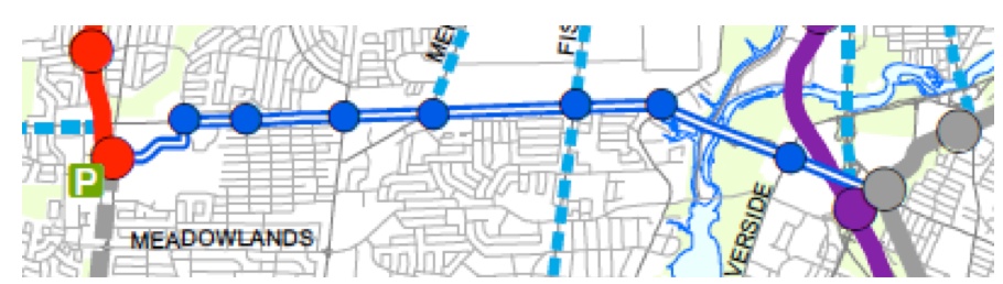
The following map illustrates what these networks might look like.
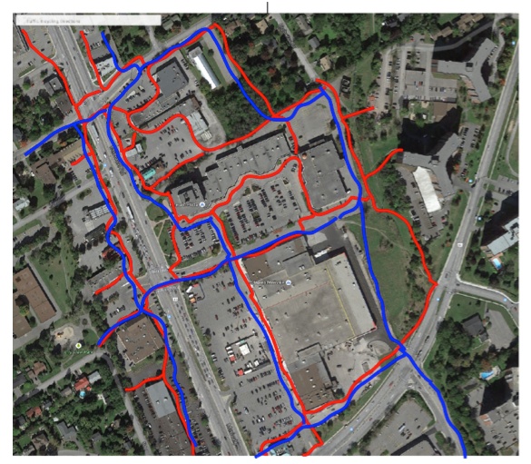
The map reveals how useless the present sidewalks bordering on Merivale truly are. There is no reason why they should not be removed to facilitate the renewal of the roadway.
Epilogue
So there it is: five ideas to trigger a public discussion on how to resolve the traffic congestion along Merivale Road and to facilitate the renewal of the whole Merivale AM zone.
The renewal of Merivale Road and the emergence of a Mid-Town around Merivale is a venture that deserves the attention of all Ottawa residents, those who live in the vicinity of this arterial mainstreet and all the others.
That’s why I believe that a public discussion would be of significant benefit. We residents of Ottawa possess an attractive city, with a great potential for growth and modernization. But with its eccentric and increasingly hard to reach downtown, it is not right now the most efficient of cities, nor the easiest one to navigate through, either East-West or North-South.
Let’s face it. The renewal of Merivale Road would not only resolve a significant local problem, a mainstreet mired in the old automobile-only paradigm, and would enable us to live in a City that works more efficiently.
Both outcomes should make Ottawa a better place to live, work and raise a family.
Terrence Lonergan is a resident of Ottawa’s Merivale Sub-area.

Comments
Be the first to comment