Unpublished Opinions

The Manotick Village and Community Association (MVCA) is a voluntary, not-for-profit, membership-based organization. The objectives of the Association are directed towards advancing the interests of the Village and Community of Manotick and the quality of life of its residents. All members, including members of the Board, are volunteers. Membership is open to any person 18 years of age or older and who has paid the annual membership fee of $10 per person. The Association has no employees.
The MVCA was founded on April 13, 2010 when the Manotick Community Association (founded in 2002) and the West Manotick Community Association (founded in 1998) were amalgamated to form the MVCA.
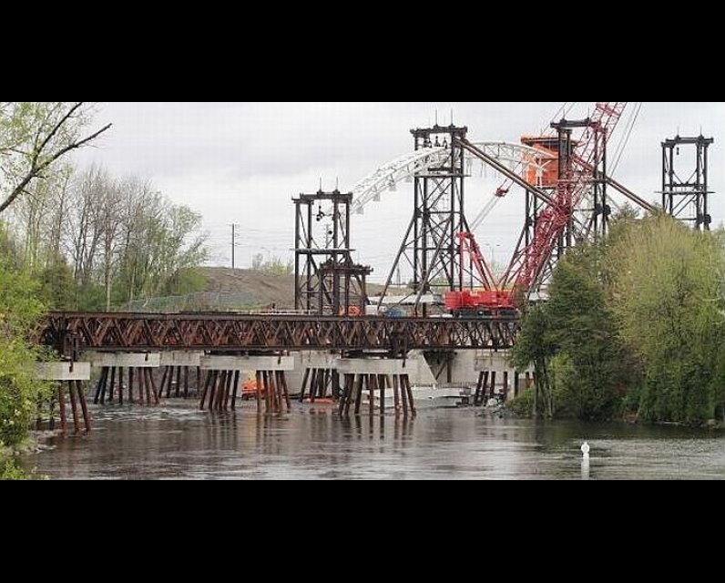
$45 million Strandherd-Armstrong Bridge a white elephant unless connected to Bank
Jim Watson, Mayor of the City of Ottawa;
cc: Councillors of the Municipal Government of the City of Ottawa; Derek Moodie, Rural Affairs Office, Pierre Poilievre, Lisa MacLeod
Your Worship:
We write to you to express concern over a recent motion (see appendix) approved by the City of Ottawa’s Transportation Committee that, if sanctioned by an upcoming vote of City Council, will have a long-lasting negative impact upon the residents of Manotick and many other communities in the southern reaches of Ottawa.
On Friday, November 15, the Transportation Planning Committee passed a motion that will reallocate funding previously approved by Council for completion of the section of Earl Armstrong Rd. that extends from Limebank Rd. to Albion Rd. This portion of Earl Armstrong Rd. is a key element in the road network that will link the two portions of the southern reaches of our city with the completion of the Strandherd/Armstrong bridge across the Rideau river.
If passed by city Council, this motion will result in a delay in the completion of this road network until past 2031 — a network design that has already been in place --and in various stages of development for-- at least twenty years. During that time countless planning decisions made by the city staff, developers and individual members of our southern communities, residential and commercial, have been premised upon the completion of this network. These planning decisions have shaped the new communities in the south of Ottawa, including Chapman Mills and Riverside South, as well as significant portions of existing ones such as Barrhaven, Manotick and Greeley.
If Council passes this motion it will negatively affect not only past planning decisions but also the future opportunities anticipated by the convenience of east-west vehicle movement across the southern reaches of Ottawa that this network was designed to provide. The cost implications of this initiative will extend far beyond the reaches of the wards in which this road network is located. For example, the loss of completion of this section of Earl Armstrong Rd. will reduce the ease of access to the amenities planned for the Rideau-Carleton Raceway for the large and growing population of the southwest region of the city. It will also affect development at and around the airport, restricting travel in the east-west direction across the southern residential and commercial areas of the city.
Delaying completion of the Earl Armstrong Rd. extension will also negatively affect Manotick in several important ways.
- For want of completion of this short section of Earl Armstrong Rd. pass-through vehicular traffic will continue to choke the residential streets of Manotick. Without the completion of this vital link in a road network city planners have invested over 20 years of effort planning and building (and that Ottawa’s taxpayers have invested hundreds of millions of dollars paying for), vehicular traffic in the south of the city will likely continue to funnel across the Rideau on Manotick’s little two-lane bridges in favor of a new, 8-line one to the north.
- Within the village of Manotick the progression of residential development has been premised upon evidence of reductions in traffic on Bridge Street anticipated following the completion the Strandherd/Armstrong bridge and its associated road network. Amendment 81 of Ottawa’s Official Plan (affecting Manotick’s Secondary Plan) includes language that requires evidence of increased capacity on Bridge Street following completion of the Strandherd/Armstrong bridge. This evidence may well be difficult to find if the Earl Armstrong Rd. link is not finished.
Without the completion of the extension of Earl Armstrong Rd., eastward the entire Strandherd Dr. /Armstrong Rd. network risks being underutilized. This may, in our view, offend provincial policy. At least it begs the question as to whether the Transportation Committee has the jurisdiction to do such violence to a part of a larger project that depends so heavily upon provincial and federal monies in addition to the financial commitment from all of the ratepayers of the City of Ottawa.
Finally, we object to the way in which this motion was prosecuted by the Transportation Committee. To our knowledge there was no publicly accessible advance notice of this motion that would provide those interested with reasonable time to prepare and present any response. We also understand that there was no opportunity for the public to provide input to the discussion associated with this motion at the meeting itself. If true these facts contradict both the spirit and, possibly, the law associated with the Terms of Reference of the Transportation Committee which, among other things, is supposed to: (7) “Receive delegations from the public and hold public hearings as required by statute and Council.” (http://ottawa.ca/en/city-hall/your-city-government/standing-committees/t...)
For these reasons we ask that Council vote down this resolution and refer the matter back to the Transportation Committee so they can complete their obligation to provide a forum where public input and consultation is allowed its proper place as a vital part of the city’s planning process.
Yours truly,
Klaus Beltzner, President
Brian Tansley, Past President
Appendix
The motion passed by Transportation Committee November 15, 2013.
(Accessed Thursday, November 21, 2013 4:30am from: http://app05.ottawa.ca/sirepub/agendaminutes/index_en.aspx)
|
The 2031 Affordable Road Network and its proposed phasing (Figure 12 and Table 4); |
|
MOTION WHEREAS the Affordable Road Network currently includes the Earl Armstrong Road project, a widening to four lanes from Limebank Road to Bowesville Road and a new two-lane road between Bowesville Road and Bank Street within Phase 3 of the draft 2013 Transportation Master Plan at an estimated cost of $43 million; and WHEREAS the Affordable Road Network currently includes the Prince of Wales Drive (1) project, a widening to four lanes from Hunt Club Road to Colonnade Road is also within Phase 3 at an estimated cost of $23 million; and WHEREAS current intersection modifications along Prince of Wales Drive, which are planned from 2015 to 2017 at a cost of $10 million, will help improve traffic flows along the most congested portions of the road, between Merivale and Hunt Club including the intersection of Hunt Club and Riverside, in the short term; and WHEREAS public consultation with residents has confirmed that a long term solution is needed on Prince of Wales Drive, and that there is strong demand for a widened Prince of Wales further south than what was planned as a priority in the current draft Transportation Master Plan’s Affordable Network; and WHEREAS the Prince of Wales (2) project, which includes a widening to four lanes between Strandherd Drive and Hunt Club Road at an estimated cost of $126.3 million, is currently in the Network Concept but not in the Affordable Network, and that, within this project, the estimated cost to widen the section from Merivale Road to Hunt Club Road is estimated at $76 million; and WHEREAS the City must continue to work within the set affordability envelopes identified for the Transportation Master Plan; THEREFORE BE IT RESOLVED that the current $23 million budget for the Prince of Wales Drive (1) project be re-allocated to widen the section further south along Prince Wales Drive, and specifically, portions of the Prince of Wales (2) project from Merivale Road to Hunt Club Road; and THEREFORE BE IT FURTHER RESOLVED that staging for the new Earl Armstrong Road, be modified so that the construction of a new two-lane road between Bowesville Road and Bank Street be deferred beyond Phase 3, and that the approximate $20 million savings resulting from this change to the Phase 3 Affordable Network be applied to complete portions of the Prince of Wales (2) project from Merivale Road to Hunt Club Road; and THEREFORE BE IT FURTHER RESOLVED that the City undertake a value engineering exercise on the Prince of Wales (2) project to identify the best value for money solution for this project, given that the full estimated budget ($76 million) is not being achieved to complete the section of Prince of Wales from Merivale Road to Hunt Club Road; and THEREFORE BE IT FURTHER RESOLVED that this value planning exercise be completed in 2014 so that it can be considered following the opening of the Strandherd Armstrong Bridge and in conjunction with the intersection modification program along Prince of Wales scheduled to begin in 2015. |

Comments
Be the first to comment