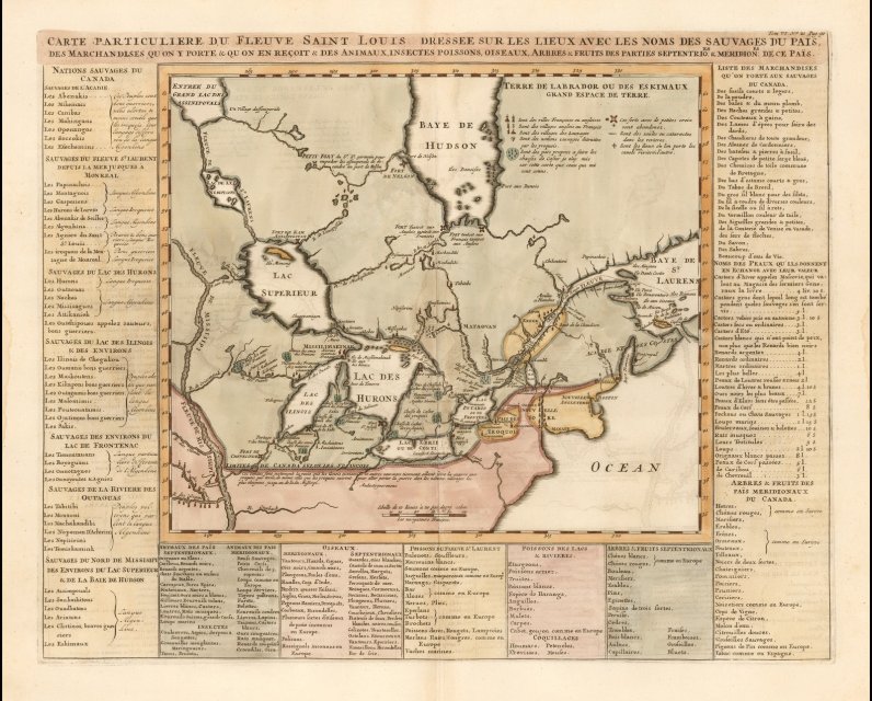
This map from 1719 clearly shows that the area we now know to be the City of Ottawa and its surroundings was known by a different name to the French 300 years ago: The Beaver Hunting Grounds of the Yroquois, or as it states in French on the map, "Chasse de Castor des Yroquois".
Earlier historical reports indicate my ancestors were well established living and hunting in the capital region in the 17th century. Nevertheless, 1719 is well before the arrival of the British into the Ottawa-Gatineau region. Negating an argument that is often made that the Mohawks migrated north with the British. This map makes it clear that my ancestors were established in this region long before the British arrived.
Jason Arbour
From the rare map website: https://www.raremaps.com/gallery/detail/52519/carte-particuliere-du-fleuve-saint-louis-dressee-sur-les-lieux-avec-les-noms-des-sauvages-du-pais-chatelain?fbclid=IwAR2gR8nQX0__Ugfn6L0PJSTo5t8ivFprb3f4pLTEYanMcAUpovzxaWXGozQ
This map is one of the best obtainable compilations of the locations of the various French Missions, forts, and French and Indian settlements during the period, and also depicts significant river crossing locations, portages and other essential travel information in the region. The search for the water route to the Pacific is still very much alive in the reports of this map, although no definitive route is shown as clearly open.
The map provides one of the most interesting depictions of the Upper Mississippi River during the time period, derived from Jolliet's rare map and report. In 1663, the French embarked on a westward expansion policy, initially focused on locating the Mississippi River, whose existence was known through Indian reports. Louis Jolliet, a fur trader and explorer, and Jacques Marquette, a Jesuit father led an overland expedition to the west, which left Green Bay in May 1673.
After following the courses of the Fox and Wisconsin Rivers, the expedition reached the upper Mississippi. Continuing south, they discovered the mouths of the Missouri, Ohio, and Arkansas Rivers. On the return trip, they found a short cut to Lake Michigan by following the Illinois and Des Plaines Rivers to a portage at
Chicago. Several manuscript maps survive based on the discoveries of Jolliet and Marquette, with this first printed version being adapted for inclusion in Thevenot's Recueil des Voyages (Paris, 1681). Thevenot's map shows for the first time on a printed map the Mississippi and its tributaries north of the Arkansas based on first-hand observation. The depiction of the river between the Arkansas and the gulf is based on speculation. It was also the first map to include the place name Michigan or Mitchigami.
The present map extends south to the Ouabach River.


Comments
Be the first to comment